Five storms predicted in the Gulf this season, says CoMET Lab
June 23, 2025
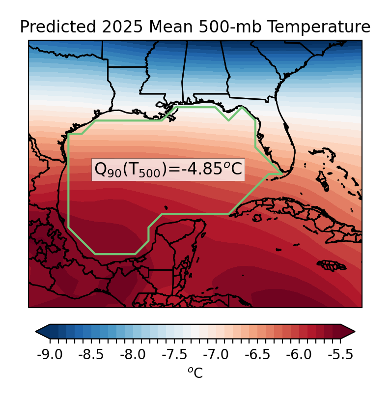
A composite of 500-mb temperatures from the seasonal weather model simulations used to generate the forecast. (The green outline shows the area averaged across for the Gulf of America.) The "-4.85C" is the temperature over the Gulf that ultimately fed into the equation to yield the prediction of 5 named storms.
– Image: CoMET Lab
BATON ROUGE - This hurricane season, five named storms are predicted for the Gulf, according to LSU’s Coastal Meteorology, or CoMET Lab, which issues a Gulf of America-specific forecast.
Five represents a slight uptick in storm activity, said Paul Miller, the head of the CoMET Lab. Miller is an associate professor in the Department of Oceanography & Coastal Sciences, or DOCS. The seasonal average for the area is 3.7 storms.
This forecast in elevated hurricane activity is in alignment with predictions for the Atlantic Ocean as a whole – NOAA has called for between 13 and 19 storms in the basin between the beginning of June and the end of November.
CoMET Lab’s forecast works a little differently than the Atlantic-based predictions.
Those models generally focus on ocean temperatures, among other factors. CoMET’s forecast, which was initially developed with Geography and Anthropology Professor Jill Trepanier, instead focuses on average atmospheric temperatures around the Gulf, approximately six kilometers, or four miles, above the ground.
Miller said he and Trepanier considered a range of potential predictive factors when they first developed the forecast in 2021, before settling on atmospheric temperature.
“What our data shows is that the warmer the temperature is, the fewer storms there should be. The colder the temperature is, the more storms,” Miller said. This link to cooler temperatures at high atmospheric altitudes may appear counterintuitive, but, he said, “think of a hot air balloon. It only works if it’s hotter than the air around it… If you go four miles above the ground, that tells you if you have a reservoir of potential buoyancy. If the air can make it to that altitude, it’s got a better chance of continuing to rise and forming [a storm].”
Normally CoMET’s forecast utilizes temperatures throughout the month of May, but due to recent changes in data available from NOAA, Miller noted that this year’s forecast is based on readings from the last two weeks of the month.